Assistant Professor of Social & Environmental Challenges
Yeung Photo Exhibit
THE LIFE AND POLITICS OF
WATER
In Peru’s Fast-Melting Andes, a Short-Term Water Surplus Spells Disaster
Peru’s Cordillera Blanca is the highest tropical mountain range in the world. Its glaciers supply a massive “water tower” that stretches across the entire continent of South America from the Pacific Coast to the Amazon Basin. These glaciers are rapidly melting under the warming climate. Farmers living immediately below its peaks are navigating a new era where glacial melt temporarily brings more water to some communities as others dry up. This photo exhibit explores how water is shaping life in the Cordillera’s northernmost province of Huaylas. Learn more with photographer Peter Yeung’s reportingPeru’s melting glaciers bring new harvests – and fears for the future in The Guardian.
Featuring photography by award-winning journalist Peter Yeung curated by Drs. Rebecca Bria and Jessica Eise of The University of Texas at San Antonio (UTSA), this exhibit was made possible by the UTSA COLFA Interdisciplinary Research Incubator Program Media Fellowship.
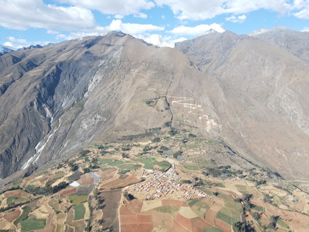
Google Earth satellite image indicating the location of the Cordillera Blanca mountain range within Peru (image 1) and satellite image indicating the where photos were taken in the northwestern Cordillera Blanca (line of white glaciers), within the region of Ancash, Peru (orange boundary) (image 2).
The Laguna Parón is one of the Cordillera Blanca’s largest glacier-fed lagoons and its water has long been a source of local conflict. Efforts to drain the lake in 1985 to control flood risks and its sale in 1996 to a private, US-based hydroelectric company both left farmers with significantly less water to irrigate their fields. Community members and local political leaders continue to fight for more control over the lagoon. The longstanding conflict exposes the contrasting priorities of energy demands, company profits and farming needs for local communities.The Comunidad Campesina de Hualcayán is a farming community of about 700 people living below the glaciated peaks of the Cordillera Blanca. Their water is brought in from a high-elevation glacial lagoon nearly 6 kilometers away, seen here cascading down the mountainside as a waterfall where it is then fed to an extensive network of terraces, many of which are more than 1000 years old.
The Cordillera’s melting glaciers are bringing abundant water to Hualcayán, but also worry about the future: “When I used to go on walks through the mountains as a child, they were completely covered in snow,” says Hugo Adriano Echeverria Paulino, speaking about the mountain peaks. “Not any more.”At the base of the waterfall, reservoirs store water for the Hualcayán community. This water is shared between all landholding families through a system of rotation called mit’a, which is a modernized form of labor rotation developed under the Inca empire.In the past two years, many families have built their own modest reservoir next to their fields to collect water during their m’ita rotation, storing it for consistent use. Such reservoirs are typically part of a “technified” irrigation system that can consistently deliver water droplets to crops through extensive tubing rather than inundating fields periodically using gravity trenches. This new system helps meet the high water demands of export crops like sugar snap peas, which international agribusinesses are encouraging local people to grow.
Water is comparatively scarce in the unglaciated Cordillera Negra mountain range, seen here across the valley. Researchers in the region predict life in the Cordillera Blanca will become much more like the Cordillera Negra once the glaciers disappear.
Gates direct the flow of water to different fields according to a community’s m’ita schedule, which is organized by a water committee. Irrigation canals are now lined with concrete, but many are refurbished ancient canals. Communities’ water rights can vary enormously across the Cordillera depending on the availability of water, with some entitled to a share every three days, and others just once a month.
“It’s easy work,” says Hugo Adriano Echeverria Paulino, a 48-year-old farmer who cultivates sugar-snap peas on seven hectares (17 acres) of land amid a breathtaking scene of snow-capped mountains and soaring valleys. “But it requires a lot of water.”In the Andes, water is life—and politics. This mural in Hualcayán is in support of political candidate “Chiki”, who was running for office as part of the Movimiento Político Regional Agua political party. “It’s a critical situation,” says Federico Chavez Salvador, the president of the Comunidad Campesina de Tzactza’s water committee, about the recent drought conditions and dwindling water supply from the glaciers, which are receding. His team attempts to improve water network infrastructure to reduce erosion and evaporation. “Industrial cultivation of strawberries and sugar-snap peas means our predicament is worse than ever,” Salvador adds, pointing to the international agribusinesses that have arrived in recent years to encourage production for export.Juan Salvador Cruz, a 77-year-old farmer in Tzactza working with his son under the beating midday heat, is attempting to irrigate a field of potatoes using only buckets of water collected by hand from a small, murky brown pool. “There’s no water, no water,” he says.
This exhibit launches in February, 2024, and is permanently housed in the McKinney Humanities Building at The University in San Antonio located at 1 UTSA Circle, San Antonio, TX 78249.